Ancient History
Glenshesk like many of the Glens of Antrim, is steeped in ancient history, much of which is still visible today if you look. Not only were the local inhabitants “leaving their mark on the land”, but with Scotland only 15 miles from Torr Head, North Antrim was the closest place to Britain, where many of the first peoples came to Ireland.
Glenshesk’s ancient history, much of it undocumented, includes ancient sites from standing stones, portal tombs and souterrains, to famous battles sites, and much. What follows is a glimpse of this story taken from various written and oral historical sources, in and about the Glen and surrounding area. A useful Link to find many of these ancient sites can be found on the Link below
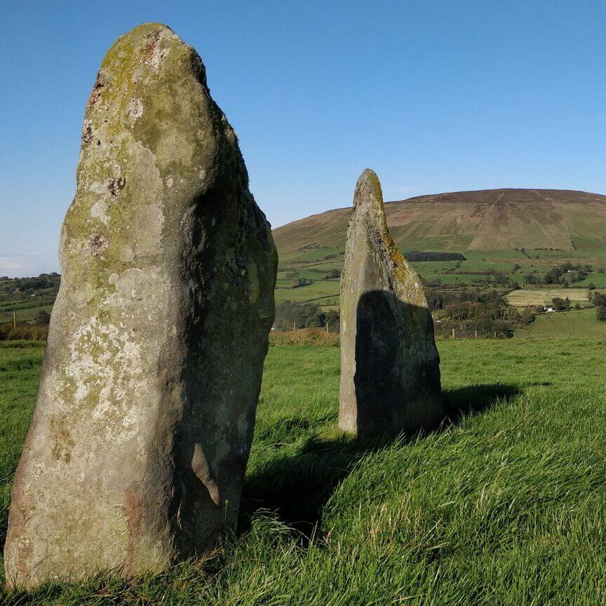
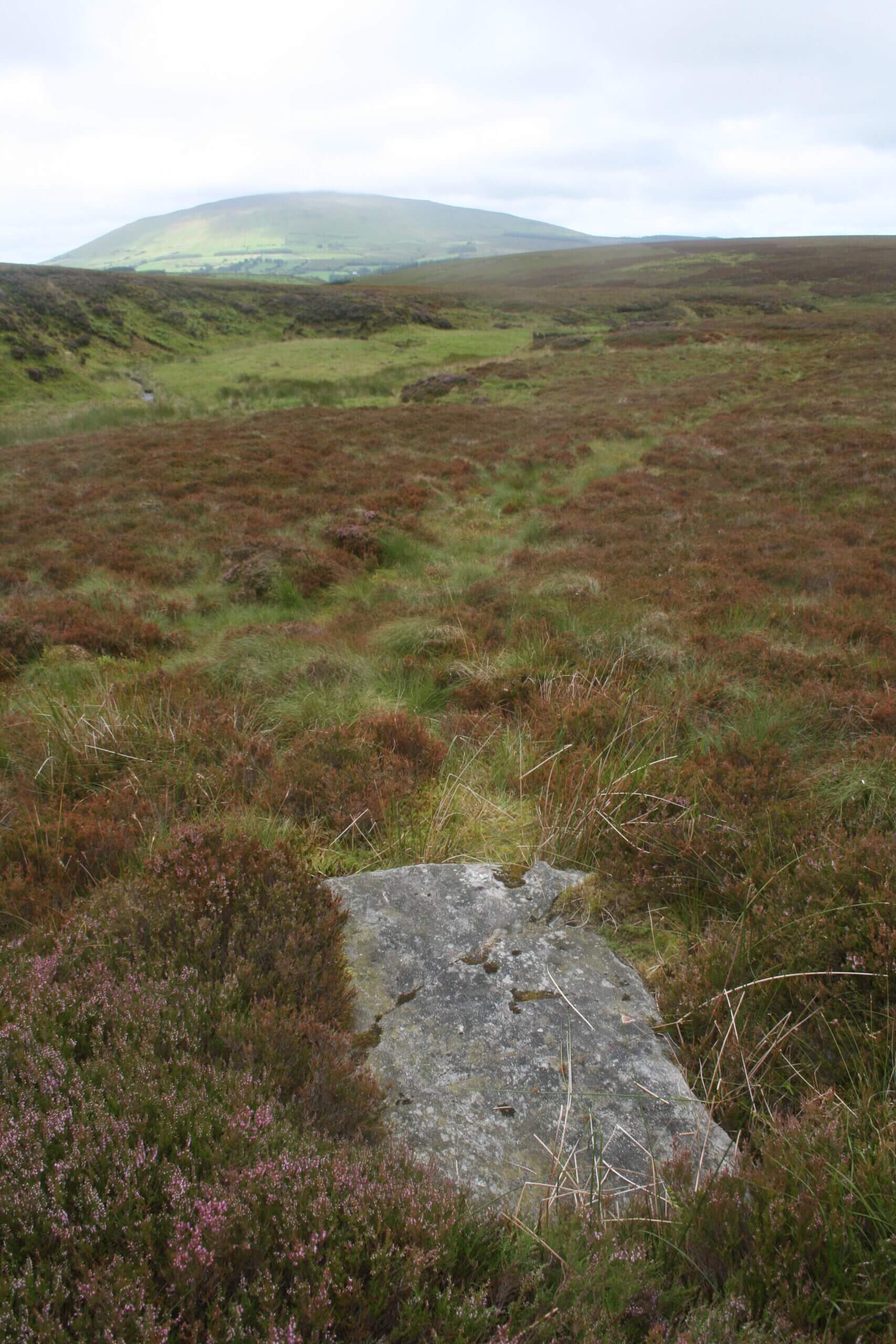
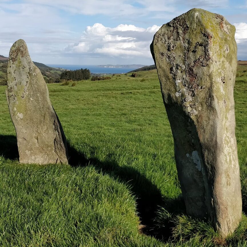
Duncarbit Standing Stones:
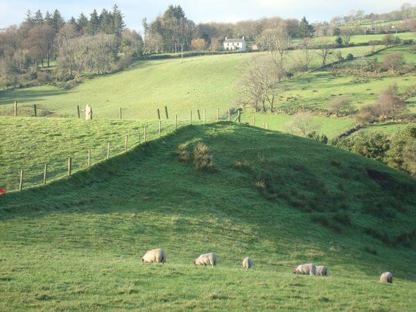
The impressive Duncarbit Standing Stones at Slaught stand just 2 metres apart, could be a portal and back stone of a destroyed Portal Tomb. The stones could have been placed here up to 3000+ years ago!
Few Standing Stones in the Glens would have such uninterrupted panoramic views down the Glen and across to Rathlin Island and beyond; see Drone Video Link below (Blue Button). Legend holds it that they mark the burial place of John Roe McDonnell, killed during the retreat from the Battle of Glenshesk.
In the same location recorded in “OS Memoirs of Ireland, Parishes of Co Antrim, 1830-1832, 1835, 1838-1839”, it states: “About 5 feet beneath the surface of a bog were found, 1831, 2 meddars of ancient butter, both decayed. Informant Con McDougle, 9th January 1839.”
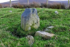
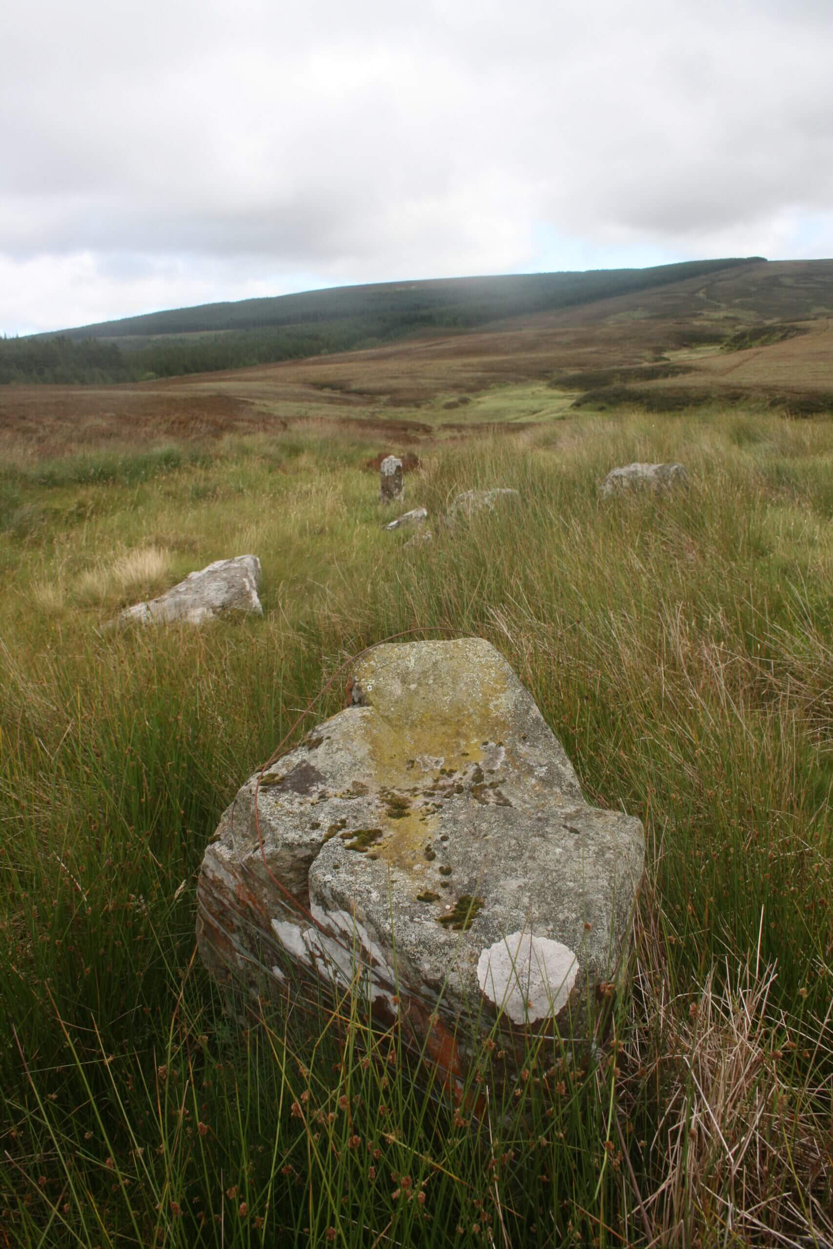
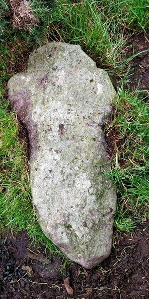
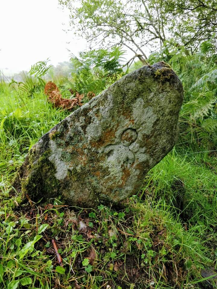
Cross-Marked stone near Duncarbit Standing Stones:
In a recent farm walk in the townland of Duncarbit, a farmer directed me to this unusual find near two other famous standing stones. There are a number of stones around the single small upright stone, and if you look carefully, a cross is incised on the flat top! This site has never been recorded on any maps, but it’s definitely of historical interest. It may be linked to the nearby burial place of John Roe McDonnell (Battle of Glenshesk). However, as coincidence would have it, I was asked by a Ballycastle historian, did I know anything of a stone seat said to be located somewhere in the townland of Duncarbit; I wonder! On the other hand, could it be a Mass Rock. A Mass Rock in Duncarbit is actually referenced by Rev O’Laverty in his 1878 book “Diocese of Down and Connor – Ancient and Modern” ; however the cross marking may have simply been added at a later date.
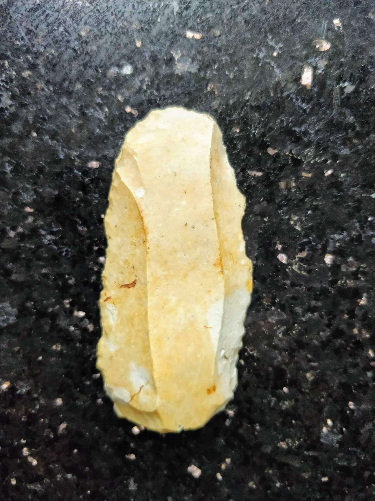
Stone Age Flints:
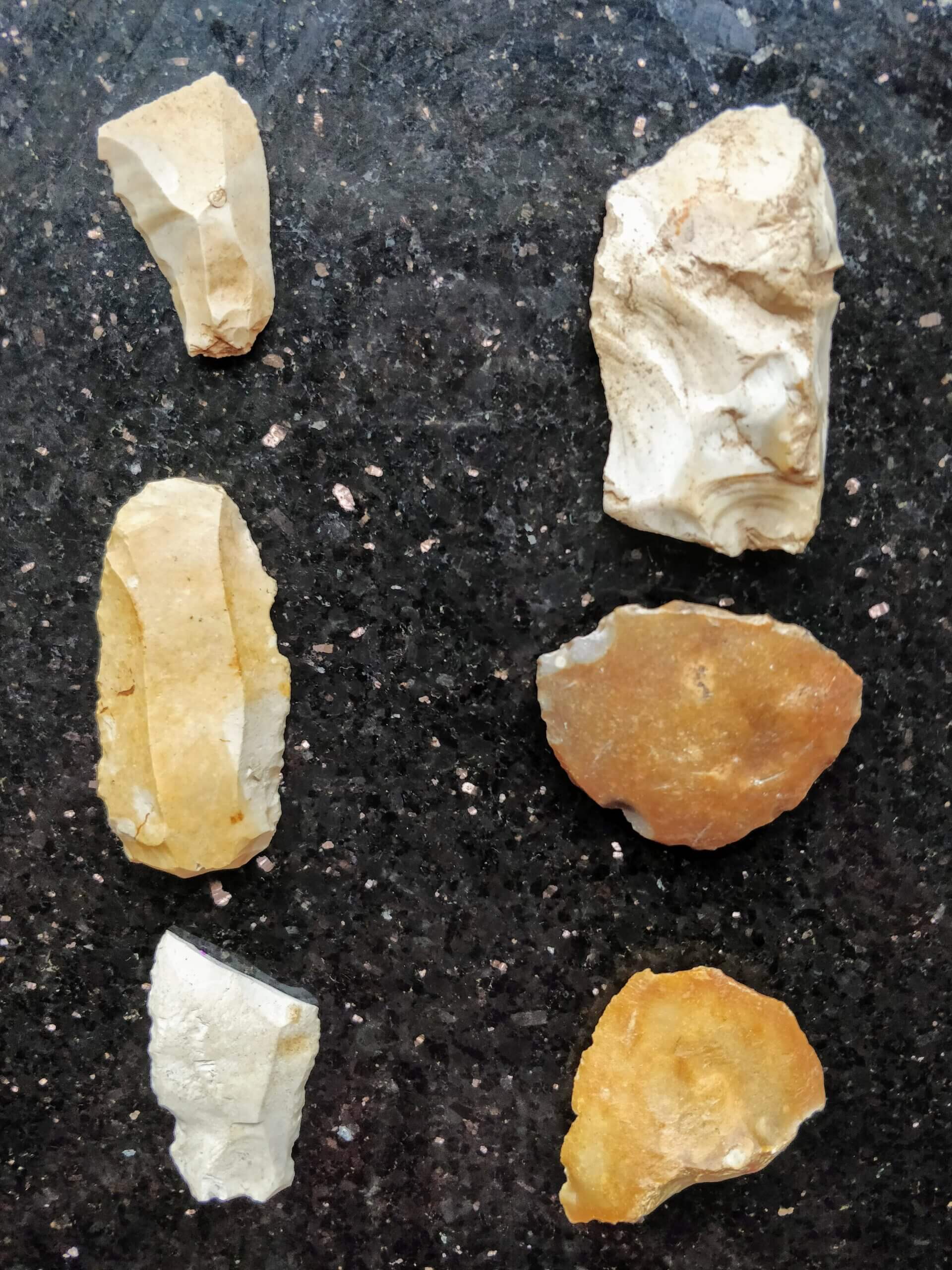
In the photographs attached we have a selection of stone-age flints lifted from Glenshesk fields, found mainly when fieldwalking to remove large rocks before reseeding after fields were ploughed. It’s amazing to think that some of these might have been made as far back as 4000 B.C.!
Flint has been used for the raw material for tools longer than any other material and fortunately for us, it does not decay. It is very hard but is easily flaked & produces razor-sharp flakes, unfortunately, it is slightly porous so that it can be flaked by thermal action (the action of frost & heat), fortunately for archaeologists when it has been struck by man there are distinctive features that help with identification.
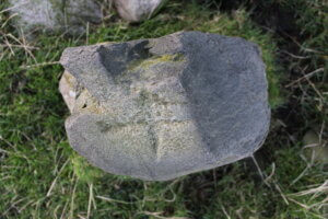
In the first group photo, the column of flints to the left (and a closeup of one in the second photo), are known as “Knives”. As mentioned, flint flakes are extremely sharp & can be used in an untouched state for cutting, but for various reasons they were regularly reworked. Some retouching was needed in order to make them easier to hold by removing a sharp edge, others were worked to make a toothed edge so that it could be used as a saw.
In the first group photo, the flints to the right are mainly “Scrapers”. Scrapers are the most common domestic tool found during fieldwalking and vary according to the intended use of the scraper.
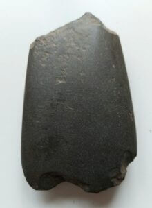
Stone Age Axe
This beautiful stone age axe was found on Clare Mountain, Glenshesk in the 1980’s during fieldwalking. It is slightly damaged at the top.
Stone axes were in use in Ireland from the Early Mesolithic period until well into the Bronze Age era. They were a common, long-lasting and functional object, which were used mainly as a chopping tool. Further to this, archaeological research has revealed evidence of development over time in their utilisation, appearance and significance, suggesting the importance of axes as both functional and symbolic objects to the people of the past.
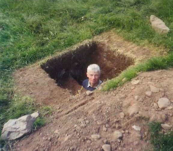
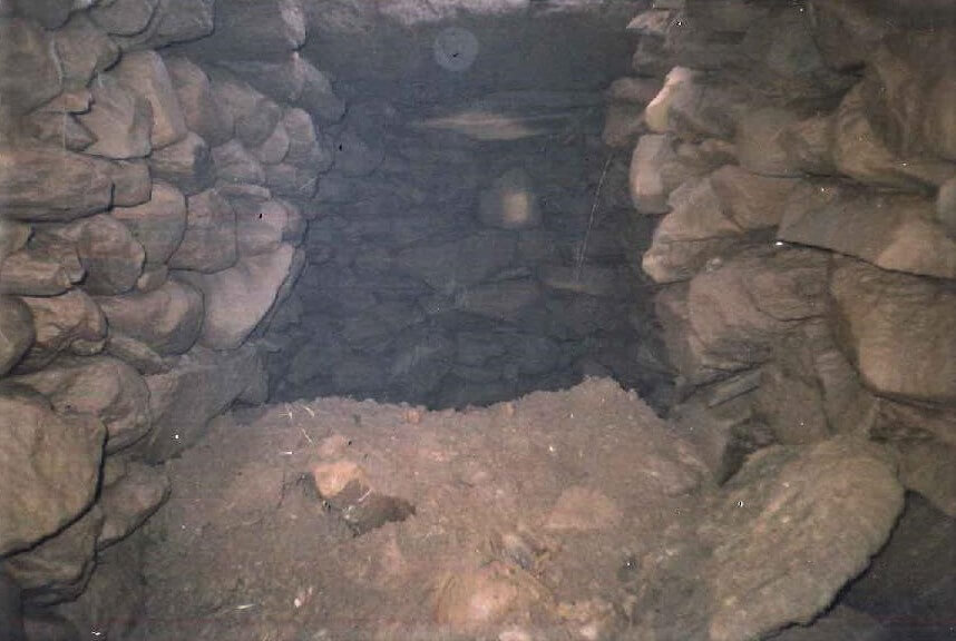
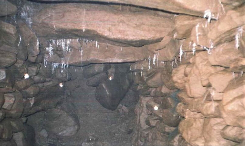
Souterrain’s
Souterrain’s (from French sous terrain, meaning “under ground”) are found across North Antrim, including several in Glenshesk itself. Souterrain is a name given by archaeologists to a type of underground structure associated mainly with the European Atlantic Iron Age. These structures appear to have been brought northwards from Gaul during the late Iron Age. It is interesting that North Antrim and Derry in particular, has the highest concentration of these ancient structures, of any part of Ireland.
At the turn of the 19th century, Francis McCaughan was gathering sheep on Broughmore braes, and came across ground that had caved in from what was reported to be a Souterrain of considerable length. However, it was deemed to be a potential hazard for sheep that might fall in, so the opening was closed over and to this day its whereabouts is not known. In 2000, Joseph Bailey discovered one on his farm in Duncarbit, Glenshesk, which was in perfect condition, and after being inspected, has been recorded and sealed again; see photographs attached. H opefully, sometime in the future, it could be examined further. No doubt, there are many more hidden underground, waiting to be discovered
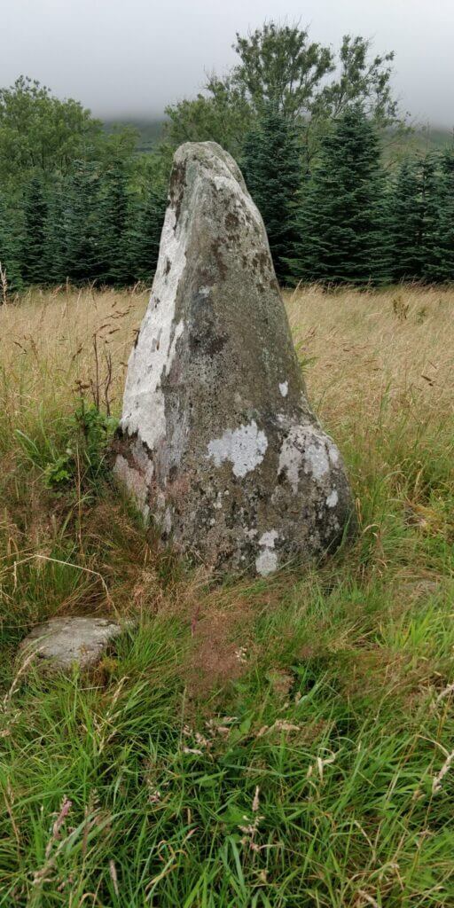
Breen Standing Stones
This is a large Standing Stone measuring 1.75 metres approximately in height. It has 4 faces tapering towards the top like a rough pyramid. It is found in a field along the laneway just before the entrance into Breen Forest
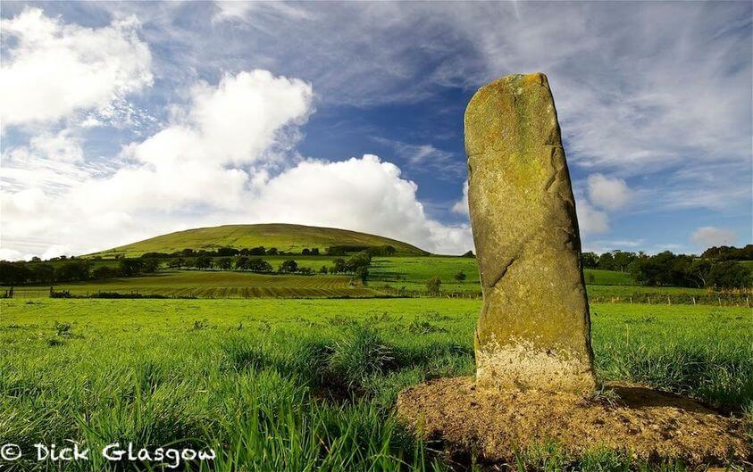
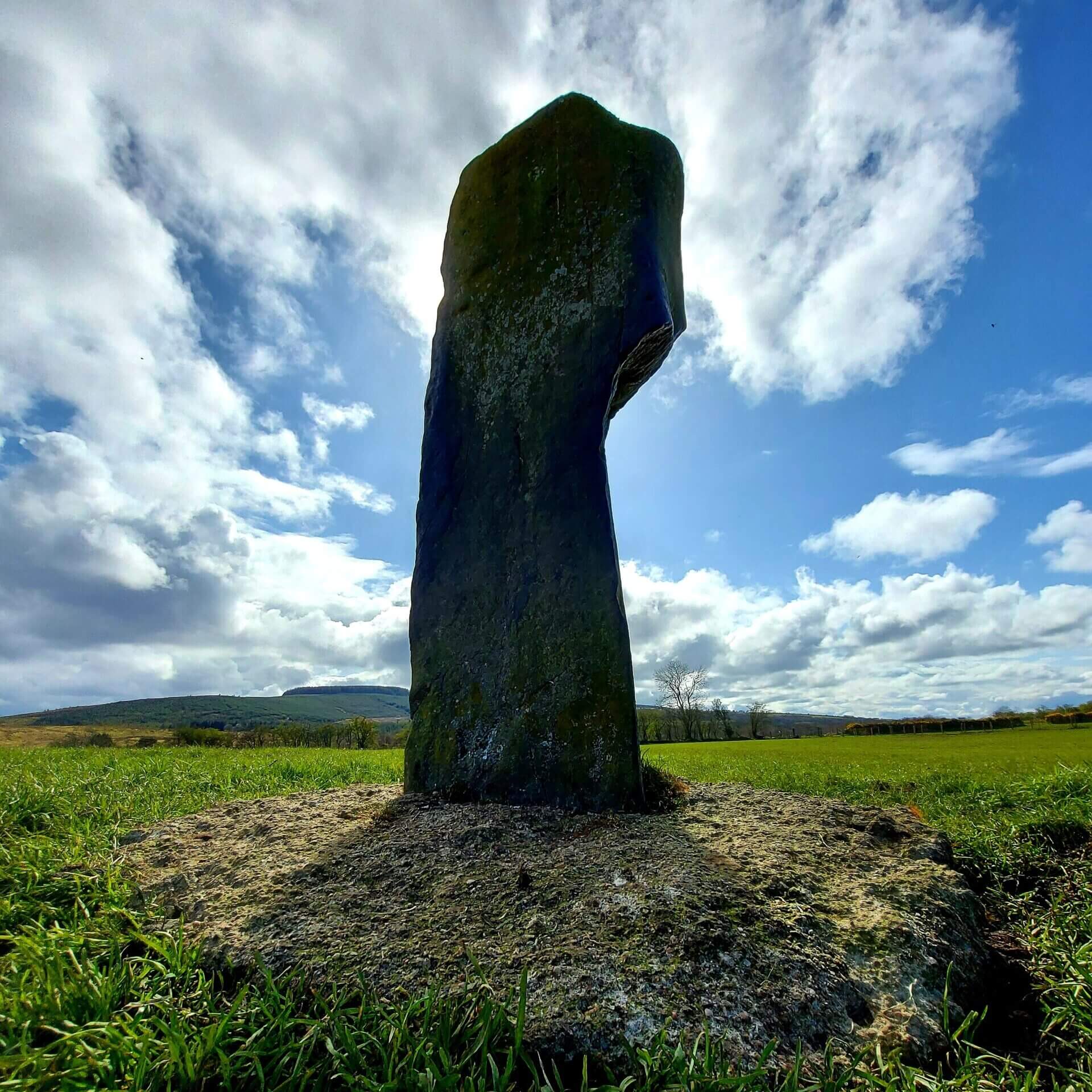
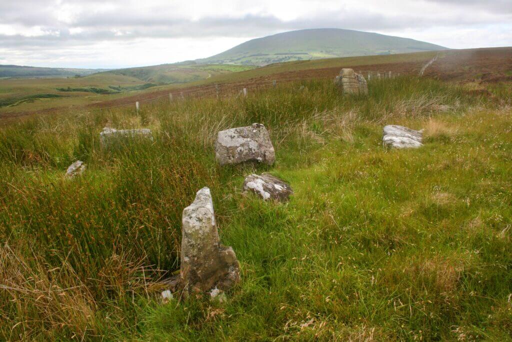
Corvally Standing Stone
Corvally Standing Stone is situated just below Knocklayde, Glenshesk, a short distance from The Church of the Immaculate Conception. Its a magnificent stone framed with Knocklayde in all its glory, in the background, and is lucky to survive in this exposed location.
Many standing stones in the middle of fields were either accidentally damaged by farm machinery, as has happened in the Glen, tumbled by farm animals who used them as scratching posts, or were moved to the side of the field. This stone had been knocked over by a bull, but was installed back in it’s original position with a little help of some concrete at its base.
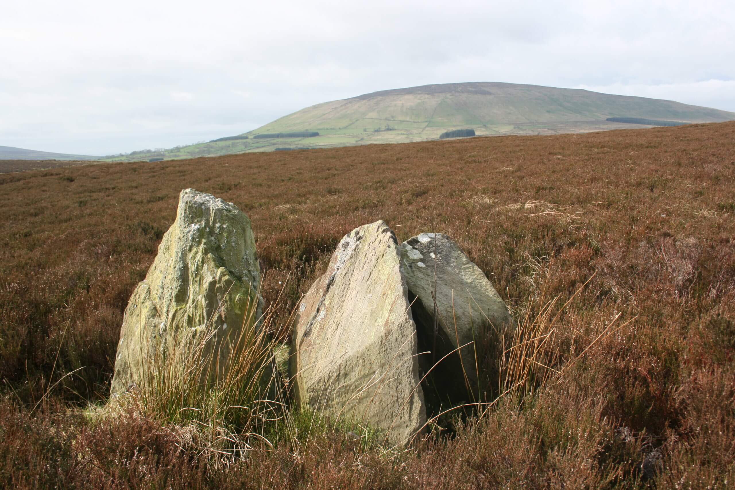
In “Diocese of Down and Connor Ancient and Modern” by Rev. J. O’Laverty P.P.M.R.I.A (published 1887), the following is given about this standing stone.
“In a bog a little north-west of the church of Glenshesk, in the townland of Corvally, is a Standing Stone of triangular shape 5 1/2 feet high, 1 foot 9 inches broad on one side and 1 1/2 feet on each of the other two sides ; twelve feet south-east of it is another that rises 2 1/2 feet above the surface; and twenty-seven feet north-east of the large stone stands a third.10 They are said to mark the spot where were interred the remains of James Anderson who was murdered for betraying the McQuillans to the McDonnells. About 120 yards south-west of these stones stands a similar stone. In this townland there are along the base of Knock-layd, the foundations of several very small ancient houses – called “Danes’ Houses; “the walls are very broad and built of large stones and clay.”
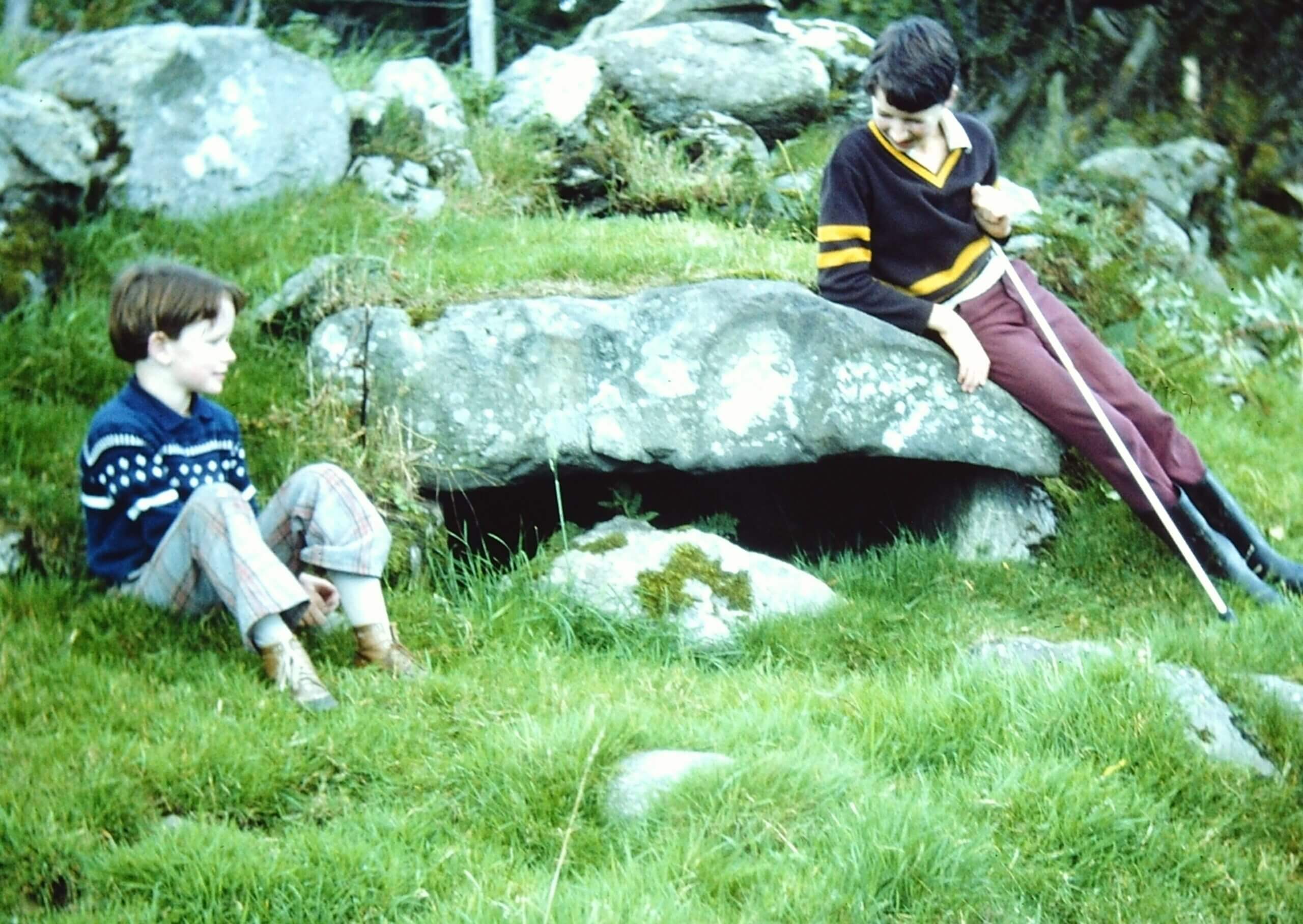
The Chieftain’s Grave
This isolated ancient grave located on Duncarbit Mountain near Ballypatrick Forest is known locally as the “Chieftain’s grave”. It was thought to have belonged to a chieftain. The Stone is actually resting on two other stones at each side and could be the entrance to a tomb, but may have sunk as it is located in an ancient bog.
At the turn of the 20th century a local farmer found what was thought to be the breastplate of a suit of armour near this location. It was taken down to Duncarbit Farm and was nailed to a barn door, where it eventually rusted away!
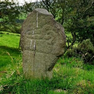
Haunton Stone
The site is known locally as “The Haunton Stone” reputedly after an early bishop is in the townland of Drumacullin. This is the very poorly preserved remains of a megalithic tomb orientated East-West with the entrance at West formed by a pair of matching portals 0.88m apart.
The North side of the tomb is formed by three stones. On the South side, only one stone is visible but a second buried stone is detectable.
Information from Dept of Communities, N.Ireland Sites & Monuments Records
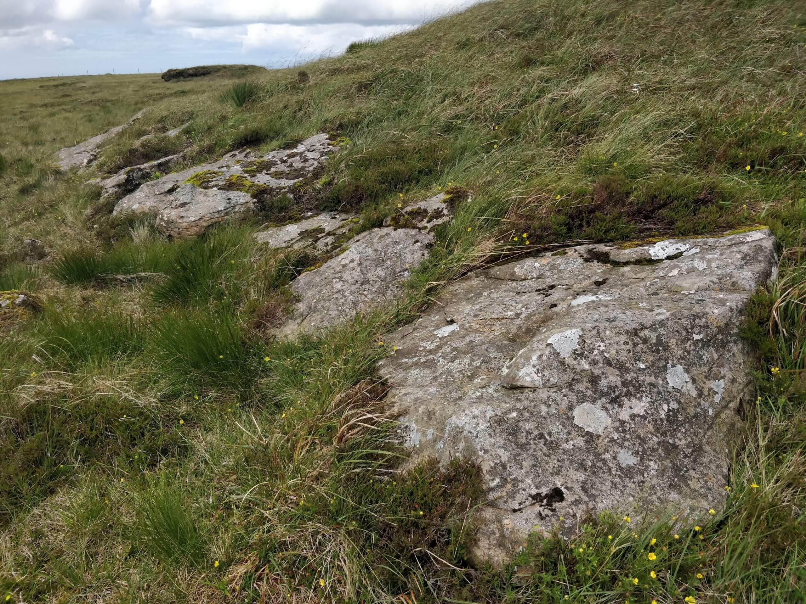
Craigban Stones
These three large stones are placed together in the Townland of Craigban, Glenshesk, and possibly are part of an ancient site, but are not mentioned on any map.
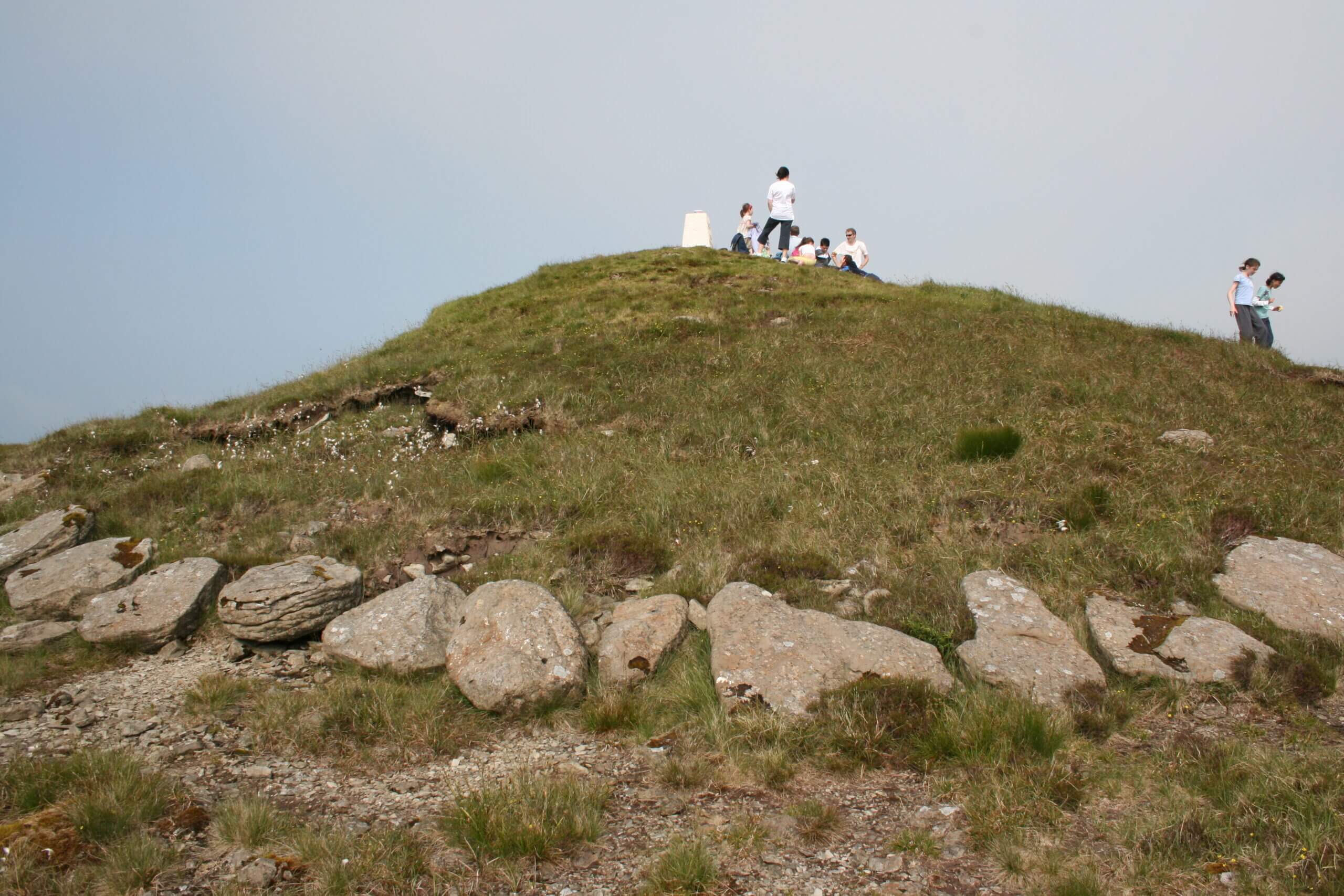
Knocklayde Cairn:
On top of one of the most dominant and highest mountains in County Antrim, Knocklayde, is an ancient Cairn that has one of the best views in Northern Ireland, looking across not only Glenshesk but County Antrim, Derry, Donegal, North Antrim Coast and Scottish Islands, and much more!
A Cairn is a megalithic type of tomb found in Northern and Western Ireland generally dating from 4,000 – 3,500 BC, but some were built as late as 2,200 BC.
At this cairn some of the stone over the centuries has been lifted away, however a lot of kerb stones are visible on one side where earth has been removed, with more buried in the soil. It is thought that the cairn may contain a passage chamber, however it has never been excavated and there is no sign of this externally. This large cairn is 15 metres in diameter and 5 metres high, and because of its size may, in most probability, may be the most important cairn in the group of cairns in this area.. The cairn is named Carn an Truagh which means the Cairn of Wow or the Cairn of the Three. There are many archaeological sites around Knocklayde, and probably many more hidden.
In “OS Memoirs of Ireland, Parishes of Co Antrim, 1830-1832, 1835, 1838-1839” it states: “On the top of Knocklayd, and about 3 feet beneath the surface of a bog contiguous to the ancient cairn, were found, 1823, 3 ancient bronze weapons resembling a dagger or 2-edge sword. Each was 1 and a half feet in length, not including the handles, for the latter were detached from the blades and not discovered at the above period. The 3 weapons were found perpendicular in the subsoil when discovered and in a perfect state of preservation. One of them is still intact in Arthur Mullan’s house, Broommore, and the other two taken away to some remote district.”
If you Click on the Link below the photographs, it will take you to an interesting Causeway Coast & Glens Heritage Trust publication titled ” A Door into the Mythological Landscape of the Glens Of Antrim” with chapter on the cairn, Page 34.
Clare Wedge Tomb:
This tomb at Clare, Glenshesk, appears to be a Wedge Tomb, but needs further investigation.
Tullaghore Crosses
The Tullaghore Crosses and are thought to be early Christian. One is a simple cross about a metre in height, currently lying flat under a whin bush. The farmer who owns the field informed me that it had fallen over, and for safety it was placed there. The other cross appears to have a carving on it shaped like a pair of shears or a hairpin.
“An older reference to them says they each topped a little cairn on the ridge, joined dumbbell fashion. Quartz pebbles are mixed with the cairn materials and this is often a feature of prehistoric mounds and megaliths” Dalriada, A Guide around the Celtic Kingdom
Both Ulster University and Queen’s University have examined the site in recent decades and the thinking is that the crosses possibly were moved here from another religious site. However, the placing of the two crosses here, suggests that this site too is important. These ancient crosses are located in Armoy Glen leading into Glenshesk.
Charles MacQuillin:
There are many hidden gems and associated stories in Glenshesk, and here is one that most people are not aware of, the ancient grave of Charles MacQuillin. The story of the death of Charles is an interesting tale, and best told by historian Robert McCahan as recorded in “McCahan’s Local Histories” by Published in 1923. The battle which Charles died at was in 1559. (Please note that there are variations in the way MacQuillin and McAuley are spelt from these accounts!)
“On the same side of the rivers bank is the grave of Charles, the second son of Edward MacQuillin. The little stone marking the grave bears on its face the initials S A M, and over these a small incised cross, while the other face has a small rudely incised face and bust.
After the battle at Ballyveely, Charles MacQuillin was watching the movements of the MacDonnells along with his servant, Patrick McAuley. A thick mist suddenly swept downward from the hills and it was their intention to reach McAuley’s house when it became worse and they finally sought shelter under a large boulder at Corvarven. Worn out by the fatigue, they fell asleep and were rudely awakened by some of the Scots who had discovered their retreat. Gasping their swords and protected by the boulder behind them they defended themselves against a violent attack until McAuley, who had fought gallantly in defence of his chief, fell, covered with wounds, but not until several of the Scots lay dead around. MacQuillin continued the unequal contest until in an effort to strike the leader of his opponent, he slipped on the wet and trodden grass and received a severe wound under the chain armour. He still held them at bay, but one of the Scots climbed the Rock and flung a stone on MacQuillin’s head which stunned him; and they then rushed forward with an excellent shout and slew the gallant MacQuillin.
There was a bewitching beauty in the lambert twilight with its faint light and soft colouring on the clouds as it lingered at eventide in this recess of the Glen, a region of silence and solitude, amid the low purple hills and moorland. Along with this great charm was associated the thought of MacQuillin, in his last great struggle for life and for his family’s rights and independence in the Route district, as he rests peacefully underneath the little stone. It was a great and intense struggle for the mastery in the series of battles between the two forces through the woods and over the rough pasture land of the Glen. The glow and excitement of battle were in their veins and both sides fought with that hard and sullen fury which they had learned from experience, and which was also the spirit of the times”
Battles in and around Glenshesk
Like a lot of North Antrim and Ireland, over the centuries there have been a number of battles which have come to shape the country as it is today. Because of North Antrim’s close proximity to Scotland, local skirmishes often involvedScottish clans from across the water; it was often easier to travel between the Mull and the Glens, than it was from the Glens to other parts of Ireland, and of course it was once part of the one Kingdom of Dalriada. There were a number of battles that took place in and around Glenshesk. These included, McQuillan v McDonnell in Glenshesk c1550s; the Battle of Glentaise, Shane O’Neill v McDonnell, 1565 which ended up in Glenshesk; and the Battle of Orra, with the McQuillans, O’Neills and English v McDonnells which was in 1559 (Source-Hill ) or 1583 (Source-Hector McDonnell). A great account of the Battle of Glenshesk can be found in the “OS Memoirs of Ireland, Parishes of Co Antrim, 1830-1832, 1835, 1838-1839” which was recorded as an oral source from several Glenshesk farmers in 1838, and is given below.
“The Battle of Glenshesk was fought in the end of autumn and about 8 months preceding the memorable battle of Aura. Both of these battles were fought between the McQuillans and the McDonnells, but the former was completely defeated by the latter at Slieve-na-Aura and subsequently established themselves on the ruins of the noble family of McQuillan at Dunluce, which properties and titles the McDonnells retain from that period to the present day. However, the battle of Glenshesk is said to have been fought sometime about the middle of the 15th century and said to have been a most bloody and well-contested battle, but the McDonnells were utterly defeated.
The battle commenced between the picket guards of both parties, who met on an eminence called Bin-Garriv, situated about 1 and a half miles south of Ballycastle. There, the picket guards fought for a few minutes before the arrival of their main bodies, but as soon as the latter forces came in contact a most dreadful combat ensued, in which the McDonnells were routed some distance southward, but were reinforced by a body of their men who, after landing at Cushendun, hastened to the scene of the action.
However, both parties renewed the combat with much vigour in a valley along the River Shesk (Glenshesk), and townland of Ballyveely, which is since called Beal-agh-na-fala or “mouth of the bloody ford”, the slaughter being so great on both sides at the latter place and the quantity of human blood spilt on the occasion so great as to change the waters of the above river to blood colour or red for a considerable distance, and from which circumstance the place has been since called the “bloody ford” as above mentioned. But the McDonnells were defeated here also and obliged to retreat still southwards to a valley in the townland of Craigbane, now called Agh-na-cavanagh or “combating valley”, so called in consequence of a renewal of the combat at that place.
Here the McDonnells met a strong body of their forces coming from Cushendun. The McQuillans too were reinforced by the country people who rallied to their assistance. However, the combat at this place was dreadful and so well contested that the slaughter on both sides became very great; but, as on former occasions, the McQuillans triumphed here also and obliged the McDonnells to fly in all directions. But the main body were pursued to a place in the townland of Duncarbit, and holding of Daniel McBride now called Turnanallibnah or the “Scotch’s bush”, where they were overtaken and cut off to a man. The place is from that period called Scotchmen’s Bush, in consequence of the number slaughtered about an ancient bush or cluster of bushes on the site.
3 of their McDonnells chieftains, to wit James, John and Randal, who endeavoured to make their escape from the final carnage, were overtaken and cut down not far distance from the latter scene of action and extraordinary bloodshed.
The grave of each noble chieftain is still visible in the neighbourhood of Duncarbit and are each distinguished by the following names and monuments: Knock-Ranill, a small cairn in Duncarbit, and holding of John McCaughan, beneath which Randal is interred; secondly, Slaught Shane Roe or “Red John’s monument”; this is John’s grave denoted by 2 standing stones situated in a bog of Drumacullin; thirdly Keeran Shemis or “James’ turf or grave”, situated in Drumacullin or Logacappel mountain and enclosed and covered by flat stones of large size. Contiguous to this latter grave were found a few years back, at some depth beneath the bog, a coat of mail composed of brass and steel rings and supposed to have been worn by the above John Roe McDonnell when killed at the later place. Some of the brass rings composing this coat of mail was in tolerable preservation and are still to be seen in the neighbourhood, but the steel rings completely corroded and run into one rusty lump.
Any other of the McDonnells or of their forces who succeeded in escaping the aforesaid slaughter repaired tio Cushendun and returned immediately to Scotland, and therefore relinquished their Irish contests for that season. Those of the 2 contending parties who fell in the battle now described were interred on the sisters of the different combats, in pits, graves and enclosed vaults according to ranks or respectability, and their graves marked out by cairns and standing stones; but most of these monuments have been subsequently destroyed. Still, the few that remain contribute to record, by local tradition, the aforesaid feudal disputes. Information obtained from John McCormick, John Brown, John McCaughan, Archibald McAlister and others. 26th and 17th December 1838.”
It is interesting the reference to the recovered coat of chain mail, which was referenced by the late Kevin Francis McCaughan of Duncarbit, who remembers the story of it being found, and nailed to a barn door for all to see! This piece also makes reference to Slaught where John is said to have been buried, in Drumacullin, but Slaught is actually in the townland of Duncarbit, in Joseph Bailey’s farm. The photos below are said to be two of the three locations of the chieftains’ graves.
In another account his time from 1887 by Rev. J. O’Laverty P.P.M.R.I.A titled “Diocese of Down and Connor Ancient and Modern” states:”
“The Annals of Lough Cé record this battle as “the victory of Glenn-Sheisg by O’Neill.” The Four Masters under the year 1565 enter:-
“”A great defeat was given by O’Neill (John, the son of Con, son of Con, son of Henry) to the sons of MacDonnell of Scotland, namely, James, Aengus and Sorley. Aengus was slain, and James was wounded and taken prisoner and he died of the virulence of his wounds at the end of a year. The death of this gentleman was generally bewailed; he was a paragon of hospitality and prowess, a festive man of many troops, and a bountiful and munificent man. And his peer was not at that time among the Clann-Donnell in Ireland or Scotland; and his people would not have deemed it too much to give his weight in gold for his ransom, if he could have been ransomed. Many others were slain in this defeat of Glenn-taisi.””
There is a difficulty about the precise site of this battle. The Annals of Lough Cé say it occurred in Glenshesk, and Mr. Hennessy, in a note to his translation of those Annals, says that the Four Masters incorrectly write it Glenn-taisi ; but Mr. Hill, who is a native of the vicinity, remarks that it must have been in the glen on the west side of Knock-layd, through which the Tow river flows. Fleming says that O’Neill camped in Ballycastle, “having his enemies within a mile in sight camping before him,” and that at 5 o’clock next morning he attacked them. Mr. Hill says – ” If the Scots had encamped in Glenshesk it is not easily understood how the O’Neills could have reached Ballycastle without a collision. But if the Scots moved forward and encamped at the foot of Glentaisi, or Glen-tow, they were thus removed to a considerable distance from the line of O’Neill’s march.” The glen through which the Tow flows has at present no name, and Mr. Hill supposes that the name of that river is a modern form of Taise. The place, however, where “John Roe,1′ who was slain in the pursuit, is said to have fallen, is in Glenshesk, on the east side of Knock-layd. If Mr. Hill’s supposition be correct, Glentaise is named from the lady Taise ” of the Fair Side, “and the fortress there built for her, was probably the great fort in Broommore.”
In other records, “The Battle of Glentaisie” is recorded again, taking place in 1565, when the famous Ulster Chieftain, Shane O’Neill defeated the MacDonnells, and captured Sorely Boy MacDonnell. Not a huge amount is known about the battle, but if you Click on the following link, you will learn a lot more about Shane who eventually was murdered in Cushendun.
Castles & Forts in Glenshesk:
Brackney Castle:
As recorded in “OS Memoirs of Ireland, Parishes of Co Antrim, 1830-1832, 1835, 1838-1839”, “In Brackney and holding Of Daniel McCahan (McCaughan), and situated on a handsome eminence about 60 yards of the River Shesk, there stood an ancient castle locally called Castle Culbert, and said to have been founded and for some time inhabited by a Culbert McKeown (one of the same family of that name who is said to have originally founded Dunluce Castle). However, of Castle Culbert, which is said to have been of considerable extent, there is not a vestige at present to be seen, save crumbles of the grouted mortar and also of tiles with which it was roofed that are still visible on site.
The later part of the foundation walls was dug out 1832. They were of great thickness and run together by grouted mortar, similar to other ancient buildings, and a large quantity of cut freestone used in their erection. In raising the ruins some years back, there was a double bust of cut freestone lifted. It was much larger than a human head and every feature well depicted in each of the faces. It is considered to have been supported on a pedestal in some part of the building. It was preserved as a great curiosity for several years in the neighbourhood but in 1832 was destroyed by neglect.
This castle stood about 1 and a half miles southeast of Ballycastle and, from its advantageous situation, commanded a fine prospect of the adjacent mountains and surrounding scenery, together with other ancient buildings, amongst which were the old castle of Duinsneey on the north west and Duncarbit Castle, which stood about 1 and a half mile to the south and situated on a loft eminence east of contiguous to the River Shesk. The later Castle was raised to the ground many years ago.
It is said by some that the above 3 castles was for some time inhabited by 3 brothers. However, it is agreed by all that those inhabiting them at some former period was leagued together for some time, and that the hoisting of a signal flag at either, in case of invasion, distress or triumph, conveyed almost instant intelligence of the same to the others who, on perceiving the signal, hoist, immediately repaired with all their forces to that place to aid in either distress or triumph as the case might be. However, the site of Culbert Castle in Brackney affords a very good prospect of the ruins of Duinaneeny Castle and also of the site of Duncarbit Castle as above mentioned.
Tradition also says that a line of paved road led direct from Culbert Castle in Brackney to Culteightrin ancient church about half a mile to the southeast. Portions of this paved road is frequently raised in labouring the ground intervening between the aforesaid 2 ancient buildings. In the ruins of the castle were discovered some portions of silver buckles and a silver coin about the size of a half-crown piece
Fort in Brackney: About 60 yards southeast of the castle stood a fort raised chiefly of earth and which seems to have been circular shape, 40 yards in diameter and from 10 to 20 feet high, but as present disfigured to some extent and occupied as a stackyard. On the east side of the fort stood a building of cut freestone and lime, supposed to have been a gateway or steps by which to ascend the area of the fort, but the latter building is now destroyed. This fort was formerly ornamented with shrubberies, flowers and grave walks, and usually called the flower garden, and supposed to have been planted by the inhabitants of Culbert Castle for their pleasure grounds. Several of the rose trees remained on it to a late period. Information obtained from Daniel and Loughlin McCahan, Neal Thompson and many others. 26th and 27th October 1838.
Duncarbit Castle:
Duncarbit townland gets its name from Duncarbit Castle (Fort of the Chariots) which stood on an outcrop just a short distance from the present farmhouse of Duncarbit. The location offers one of the best commanding views of the entire glen, and is the reason why the location was chosen for a castle. Having a 360 degree view, it was an ideal spot to survey all around you, including any possible approaching enemies! The site is said to date from the 15th/16th Century and may have been a wooden structure, but nothing remains of it now. In 2000 Brian McCaughan erected a standing stone (the Millennium Stone) at the head of the hill where the fort stood, to mark the beginning of a new millennium. Local historian, the late Cathal Dallat noted that at one time the remains of a chariot were found in a cave at Doonfin, and wondered if there was a connection to the Fort of the Chariot?
The “OS Memoirs of Ireland, Parishes of Co Antrim, 1830-1832, 1835, 1838-1839”, talks in detail about the castle: “In Duncarbit and holding of Archibald McAlister, and on an eminence east of and contiguous to the River Shesk, there stood a large and well-fortified fort which gave name to the above townland and beneath which stood several caves, but all at present disfigured and the site under tillage.
Contiguous on the south side also stands in the same townland, and holding of John McCahan (McCaughan), a loft eminence on which stood an ancient castle locally known as Duncarbit Castle, but of which there is not a vestige at present to be seen. The site is now designated the Burnt House, in consequence of a house being consumed by fire there some years back. However, of the period of the erection or destruction of the castle, there is little known detail to be found, save that a feeling of it’s erection by the McKeowns of Brackney Castle prevails in the neighbourhood and also of its being latterly inhabited by one of sons of McAlister who, in the reign of Elizabeth, were numerous and possessed strongholds in this portion of the country.
It is also stated, in consequence of the vicinity of the castle to the River Shesk, situated in a valley to the west side, that McAlister had a fishing net constantly set in the river and attached by a train of cords to the castle bell, so that the fish caught in the net, which struggling to extricate themselves, caused, by the pulling of the cord, the bell to ring and thereby announce their own detection. The inhabitants of the castle, knowing the cause of the bell ringing, subsequently repaired to the net and took therefrom the fish caught,; and by this arrangement they had a constant supply of fresh fish in season, without encountering the fatigue commonly attendant on ordinary angling. Such fishing arrangements as that now described is also said to have been connected with Brackney and other ancient castles situated on the banks of fresh waters in this portion of the county.” The article goes on to repeat, as mentioned previously that local tradition stated that Duncarbit and four other castles at Breen Castle in Loughguile, Brackney Castle, Duinaneey Castle and KInbane Castle were inhabited by the McAlister brothers, and were able to signal each other using flags when need be. This information was given by Donnel McCahan (McCaughan), Archy McAlister and others.”
In the same document, it mentions another fort: “In Duncarbit, and holding of Con McDougle, there stands a small oval fort situated on the summit of a lofty pile of rock. It stands 7 and 5 yards on the top but does not seem to have been surrounded by either moat or patapat, but is said to be very gentle and often seen illuminated by night. In the above Con McDougle’s house there is an ancient quern of a very hard kind of mountain freestone and found about 5 feet beneath the surface of a sandy hill. It is 1 and a half feet in diameter and 5 inches thick. 4th January 1839”
Ancient Graveyards:
Apart from the individual graves of chieftains and those slain in various battles as mentioned above, there are a number of ancient graveyards scattered across Glenshesk, most of which are no longer evident.
Craigban: In “OS Memoirs of Ireland, Parishes of Co Antrim, 1830-1832, 1835, 1838-1839” we have an account of one at Craigbane: “In Craigbane and holding of John Delargy, there stood an ancient graveyard which is now defaced, but in the reclaiming of which were discovered several graves, rude headstones and decayed human bones. One of these graves found about 2 feet beneath the surface, 1827, was enclosed and covered by flat stones and contained a human skeleton, the bones of which was of a rather unusual size. Their bones were again interred on the site where found. Informants John Delargy, William Simpson and others, 22nd and 23rd November 1838”
Broughmore: Later it goes on to mention one at Broughmore: “In Broughmore, and holding of George Brown, there stood an ancient graveyard locally called Kille-asturrick, so called from a lofty eminence on which it was situated. However, it contained about a quarter of a rood of ground and was well occupied by graves of different sizes, but all at present defaced and the site under tillage. In reclaiming the place 40 years back, there were quantities of every description of human bone found beneath its surface and some of which were of large size and supposed to be the bones of persons who fell in an ancient battle fought near that place between the McQuillans, O’Neills and McDonnells.
In the above townland, and in different parts along the banks of the River Shesk, were also found from time to time several pits, vaults and graves containing human bones, generally supposed to be those of people who fell in the aforesaid battle. Some of the graves and vaults were enclosed and covered by flat stones, but in other instances bones were found in sunk pits without any enclosure of stones about them. Informants, John Delargy, Archibald McAlister and others. 24th December 1838”
It should be noted that local tradition has it, that this grave site at the top of Broughmore is in fact a cillín (plural cilliní). A cillín is a historic burial site, primarily used for stillborn and unbaptized infants.
Duncarbit: The same document goes on to talk about the graveyard at Killeluke in the townland of Duncarbit: “In Duncarbit, and holding of Patrick McBride, there stands the remains of an ancient graveyard called Killeluke. This graveyard is said to have been of considerable extent, but at present occupies only 12 by 10 yards of ground which is grown over by a scrag of sloe bushes and some rude headstones appearing through its surface.
In labouring the ground round the present remains, and at several yards distance from it, are frequently discovered beneath the surface small standing stones supposed to have been placed at the heads of graves, and also some decayed bones. In the recollections of the present generation none other than stillborn and unbaptised children have been interred here, neither is there any local idea of an edifice being in the place at any period. However, on the north side, and immediately adjoining the present remains of the graveyard, stood 2 sections of caves situated nearly east and west, and detached a few feet from each other but seeming to have been connected at the east end and one sunk considerably deeper in the ground than the other.”
A few years ago in the 2010’s, in a field above the graveyard was discovered a Souterrain , which after being examined has been covered up for safety. However the Ordnance Survey document seems to hint that this structure, or one similar, had been known about in the 1830’s, although it is described as a “cave”, but is stoned lined! The “cave now extant is 15ft long, 4 and a half feet high and averaging 3 and a half feet wide. When discovered, the floor was quite hard and smooth but subsequently destroyed in digging it up in search of money. There were 4 oval stones, weight from 7 to 10 lbs, found lying on the floor. One of these remains in the cave. The walls of the cave are of dry stonework and roof composed of long flat stones. The other section of the cave is nearly destroyed. It seems to have been 25 feet long and 2 and a half feet wide and to have formed a communication from the graveyard into the former section, which is sunk much deeper than the latter. This subterraneous building has been designed perhaps for some ecclesiastical purposes in connection with the burial ground…. Informants Patrick McBride, Patrick Brown and others, 13th October 1838”.
Greenans: “In Greenan, and holding of Edward O’Connor, there stands the remains of an ancient graveyard locally called Kille-Mayangee. A large portion of this graveyard is situated about 6 feet beneath the surface of the solid bog and has been discovered in cutting turf there from time to time. However, from the detached manner in which the graves and headstones are situated and occasionally discovered here, it would appear that the graveyard originally occupied about 4 acres of ground. Several rude headstones at present standing both in the remains of the bog and also in the reclaimed part of it vary from 1 to 6 and a half feet in height. Here are also visible on the subsoil beneath the bog the ruins of a stone fence. The graves frequently discovered in labouring the ground are in all cases enclosed and covered by flat stones.
Detached a short distance west of the bog stands a small sandy hill, which seems to have been artificially raised and beneath the surface of which was discovered, within the last 2 years, several vaults enclosed and covered by handsome flat stones supposed to have been carried from a neighbouring river for that purpose. In some of these vaults are found quantities of large but decayed bones and ashes, and in others earthen urns containing bones and ashes also. The bones both in the vaults and urns, were mixed with a reddish light sort of sand, supposed to have been placed there for preservation. The urns were very handsomely carved on the surface. One of the latest found is in the possession of Mrs Cuppage of Glenbank and another in the possession of Mt Charles Kirkpatrick of Ballycastle.
The last of the vaults discovered, and yet undisturbed, measures 3 feet 8 inches long, 2 feet deep and 1 foot 10 inches wide. The flat stone by which it was covered is 5 feet 4 inches long, 3 feet 8 inches broad and nearly 6 inches in thickness. This vault contained both urn and bones put up in the aforesaid description of sand, and some of which still lie in the interior of the vault. Over these vaults stood a paved causeway, independent to the flat stones immediately closing them, and it is supposed several vaults are yet undiscovered in the hill before mentioned.
The graveyard stands on an eminence east of and contiguous to the River Shesk, and nearly opposite to the Glenbank House. The portions of the urn… have been found on the above graveyard and will show the carving on their surface. some of them are nearly an inch thick and would hold 1 to 4 quarts. Informants Edward and John O,Connor and others. 15th October 1838” (Source: OS Memoirs of Ireland, Parishes of Co Antrim, 1830-1832, 1835, 1838-1839)
As discussed previously under the section History – Ancient History, there are a number of ancient graves across Glenshesk, ranging from standing stones to megalithic tombs. One unusual possible grave which is mentioned in the “OS Memoirs of Ireland, Parishes of Co Antrim, 1830-1832, 1835, 1838-1839” is in a field called “Uaigh” (grave) which gives its name t the bungalow presenting standing there. The reference states: “Archibald McAlister of Drumacullin, in labouring hir farm an the above townland, 1834, discovered about 2 and a half feet beneath the surface a grave 8 feet long, 3 feet wide and about 1 and a half in depth, and containing a quantity of rich black earth. It was enclosed by handsome flat stones and covered by a large stone of the same description. The site of this grave was always called Oya-vic-namore, “the son of the big’s grave.”” It is interesting that in the late 1980’s whenever the field was being cleared for the building of a new house, several very large stones were found together. Some were incorporated in the rockery in the garden and another, pictured, was moved to a nearby location in the field.
Corvally, Kille Phaul: “In corvally, and holding of John Boyd, there stands the site of an ancient graveyard locally called Kille Phaul. Beneath the surface of this graveyard were found at different periods 3 earthen urns, containing each a quantity of calcined bones and ashes. Here is also several vaults or graves, enclosed all round by flat stones and covered on the top by long flat stones, and each containing a quantity of rich black earth and some remains of the human bodies in a decomposed state. The graves varied from 5 to 7 feet in length and about 2 feet in depth and width, and enclosed and covered by large and well-shaped stones. 2 of these graves have been discovered on the present date. They are frequently found about 2 feet beneath the surface.
In this place also stands 2 caves, constructed similar to other before described and containing different apartments. In one of these caves, detached a few perches from the site of the graveyard, there were found some years back some earthen urns containing calcined bones and ashes. The latter urns were carved on the surface but the former quite rude. The caves are not closed, save a few feet at the entrance to each. Informants John and Willian Boyd. 8th September 1838.” (Source: OS Memoirs of Ireland, Parishes of Co Antrim, 1830-1832, 1835, 1838-1839)
Kilrobert: “Tradition has it that there was an ancient burying-ground in Kilbobert, but no traces of it can at present be discovered” (Source: Diocese of Down & Connor, Ancient & Modern – Rev J O’Laverty
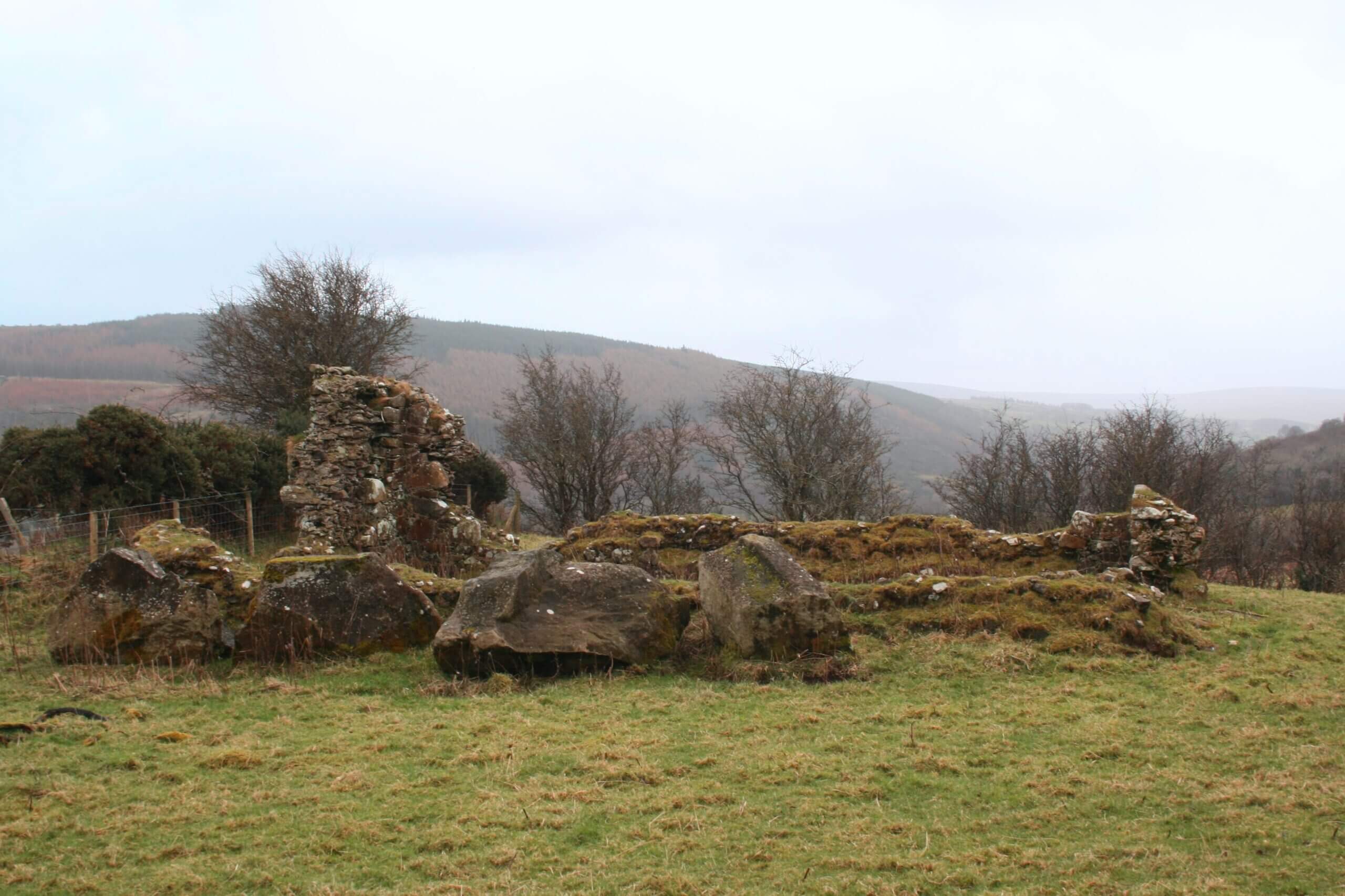
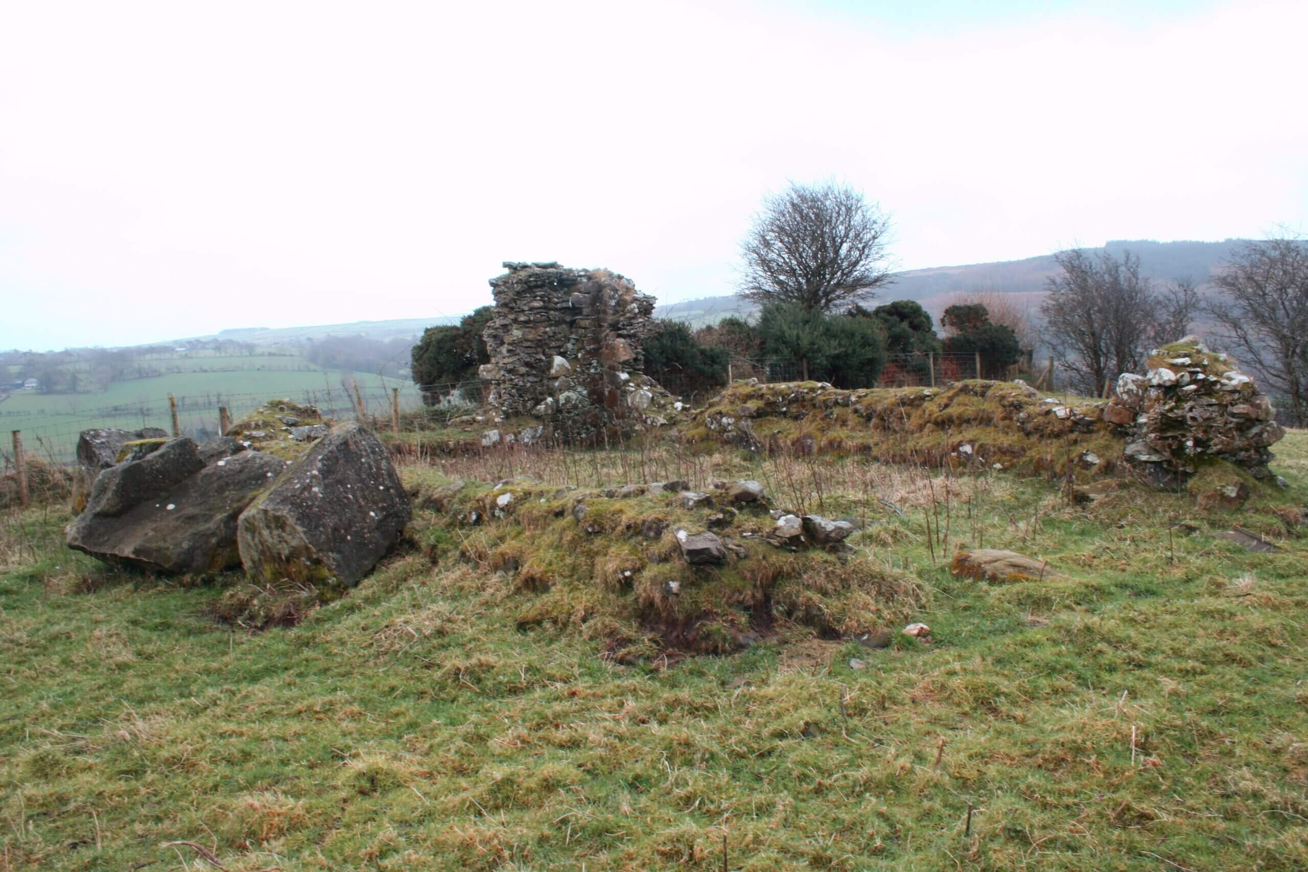
Goban Saer’s Castle.
“Near the foot of the hill (Cool Brae) is the path to the ruins of a Church on an eminence locally known called Goban Saer’s Castle, and near which was an older Church of which there is scarcely now a trace, known as Kill-Enan, founded by St Patrick and to which he appointed St Enan as it’s first pastor. The Church measured 28.75ft in length and 15ft wide and its walls were 37″ thick. It was built with dressed sandstone, having irregular and closely fitting joints” (M’Cahan’s Local Histories).
“At the end of a ridge overlooking the Shesk river at Drumeeny are the ruins of a small ancient church. It is commonly called Govan Sayer’s Castle. Govan Sayer was a mythical character, equivalent to the famous Daedalous (the artful) of Greek myth, Govan Sayer’s name is a composite of Gobhan (smith) and Sair (carpenter) and he is said to be responsible for building churches and round towers. One of the older names of the place is Govan Sayer’s Daughter’s Castle. Goven Sayer’s daughter is also credited with building monuments, especially the extremely impressive round tower at Monasterboice, but the name could also mean that this was originally a foundation for nuns. The ruin of a megalith, possibly a portant grave, lies a few metres to the North of the church on both sides of the hedge. Two taller pillar stones lie in the field boundary and immediately over the hedge, there is a large flat block which would be ideal as a capstone. In the light of the reuse of ancient sites by the early Church and the prominent position of the site, the idea of continued use of a ritual place with very early beginnings is extremely likely.
This is also the site of a graveyard, headstoneless because headstones were not in common use in Ireland until the 19700s. Before that, people were buried in unmarked graves in consecrated ground, or frequently in common ground which was used for grazing. There are also records of a souterrain which has a cross-carved stone used as one of the roof lintels, but the entrance has been lost. This feature would suggest that the original cross-slab of the site (450 AD) was reused in the construction of the souterrain (700 AD).” Dalriada, A Guide around the Celtic Kingdom, JDC Marshall
If you CLICK on the Link below the photographs, it will take you to an interesting Causeway Coast & Glens Heritage Trust publication titled ” A Door into the Mythological Landscape of the Glens Of Antrim” with chapter on Goban Saer, Page 30.
Religion in Glenshesk over the centuries has played a major part in the history of the Glen, from ancient crosses, Mass Rocks, Bonamargy, Ardagh, Culfeightrin, to the Church of the Immaculate Conception. Click the BLUE Button attached to learn more